Gravel cycling creates a specific navigation problem that road apps were never built to solve. Komoot's 160,000+ community gravel routes include surface breakdowns showing paved, gravel, dirt, and singletrack sections on the elevation profile before you commit to the route. RideWithGPS added its Surface Types feature in 2025 specifically because the bikepacking and gravel community needed to know where the tarmac ended before departing on a 200 km overnight ride. Neither feature exists in Strava, Garmin Connect, or any app designed for pavement-only cyclists. After testing 10 apps on Pixel 8 and Samsung Galaxy S24 running Android 15, across gravel and mixed-terrain routes in 2025, I found five that consistently serve adventure riders from day rides to multi-day bikepacking routes.
The core insight from testing: gravel riders typically need two to three apps covering route planning, navigation, and community, because no single platform handles all three at adequate depth.
Who this is for: Cyclists who regularly ride on mixed surfaces, including gravel, dirt, and unmaintained tracks, ranging from day gravel riders exploring local forest roads to bikepackers planning multi-day self-supported adventures. If you ride primarily on tarmac, the recreational cyclists guide or serious road cyclists guide covers your needs more accurately.
What Gravel Riders Need That Road Apps Don't Provide
Road cycling apps measure power, pace, and elevation on predictable surfaces. Gravel and adventure riding introduces three additional requirements that road tools cannot address.
Surface Knowledge Before Departure
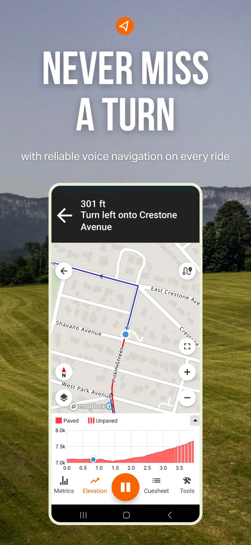
A gravel rider planning a 120 km loop needs to know before leaving home whether kilometer 47 is rideable dirt or loose rock that requires pushing. Road apps treat all surfaces as equivalent tarmac and cannot distinguish a smooth gravel road from a rutted farm track at the route planning stage. Komoot's surface-aware routing engine and RideWithGPS's Surface Types feature both show this breakdown on the elevation profile, letting you identify problematic sections and adjust the route before riding rather than discovering the problem mid-adventure with no easy alternative.
Reliable Offline Navigation
Gravel routes frequently cross areas with limited or no cellular coverage: remote forest roads, agricultural regions, mountain passes, and backcountry terrain where streaming map data stops working exactly when you are most lost and most need it. A navigation app that requires signal is a liability on any gravel route beyond familiar local roads. Gaia GPS's offline topographic maps, downloaded before departure, continue working through areas without coverage; Komoot's offline map download covers the specific region you plan to ride. Both are baseline requirements for adventure riding, not optional upgrades.
Multi-Day Route Architecture
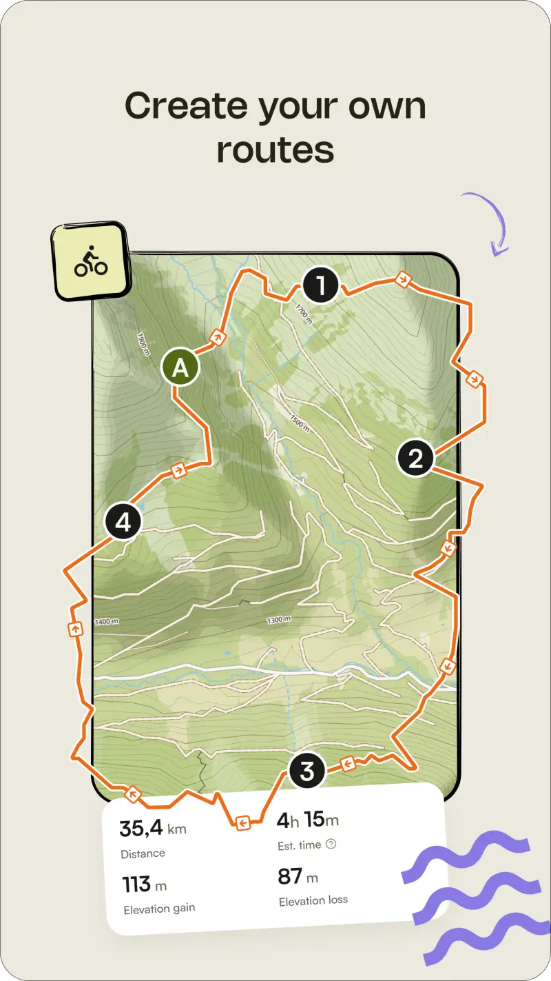
Bikepacking routes spanning 2-5 days require waypoints at resupply points, accommodation, water sources, and campsites, alongside the main route line. RideWithGPS's precision route editor handles this level of complexity with drag-and-drop waypoint placement and custom point-of-interest creation. Standard cycling apps that draw routes from A to B without waypoint management work adequately for day rides but break down when planning a 400 km multi-day adventure with specific intermediate stops.
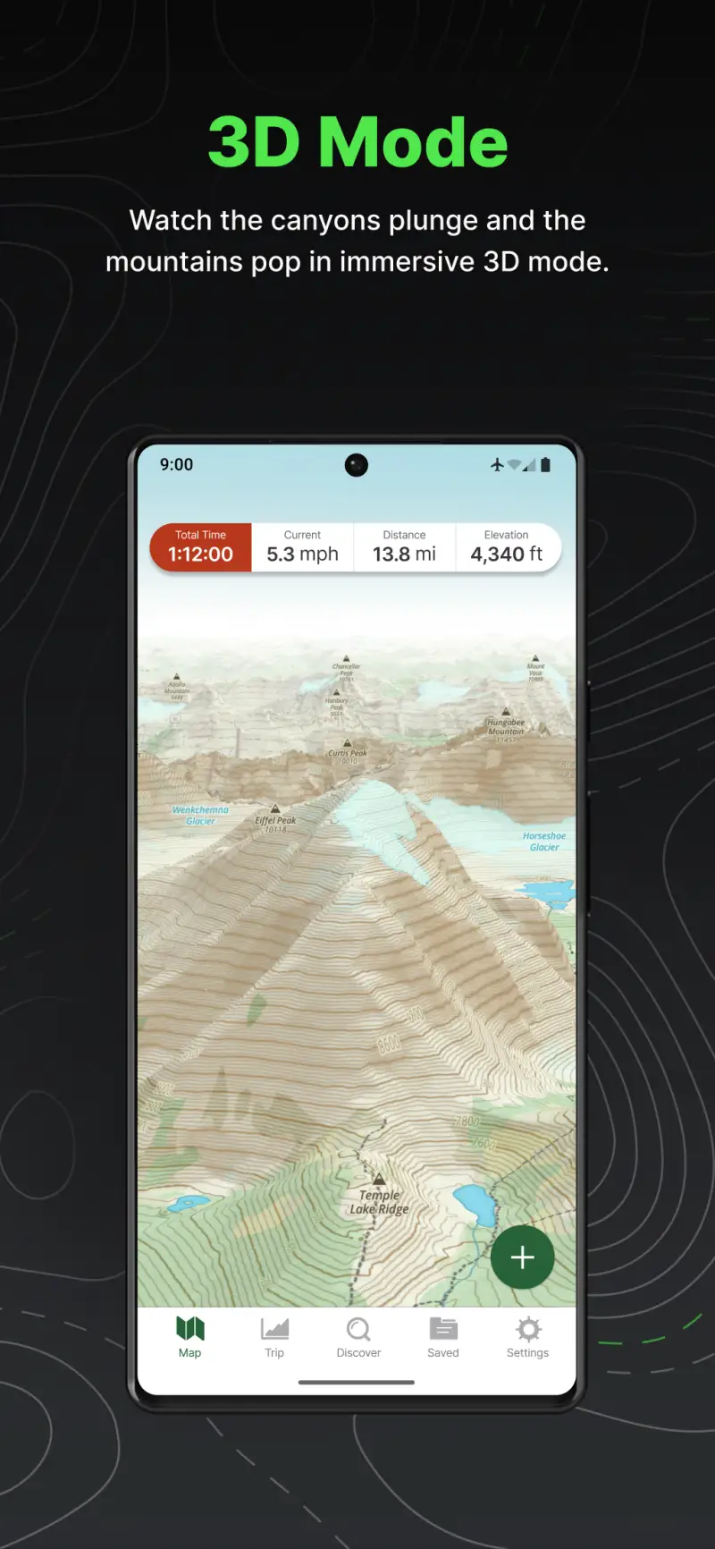
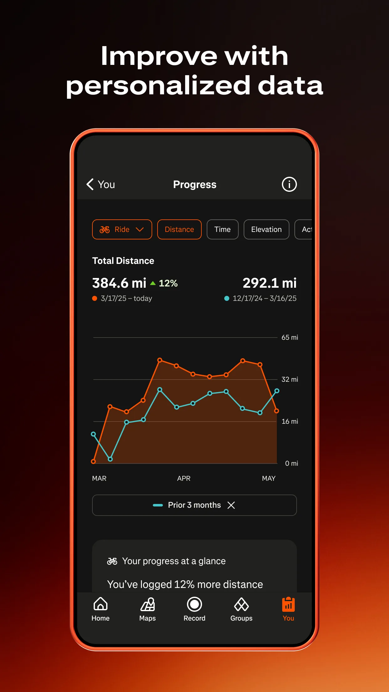
Komoot - Best for Surface-Aware Route Planning
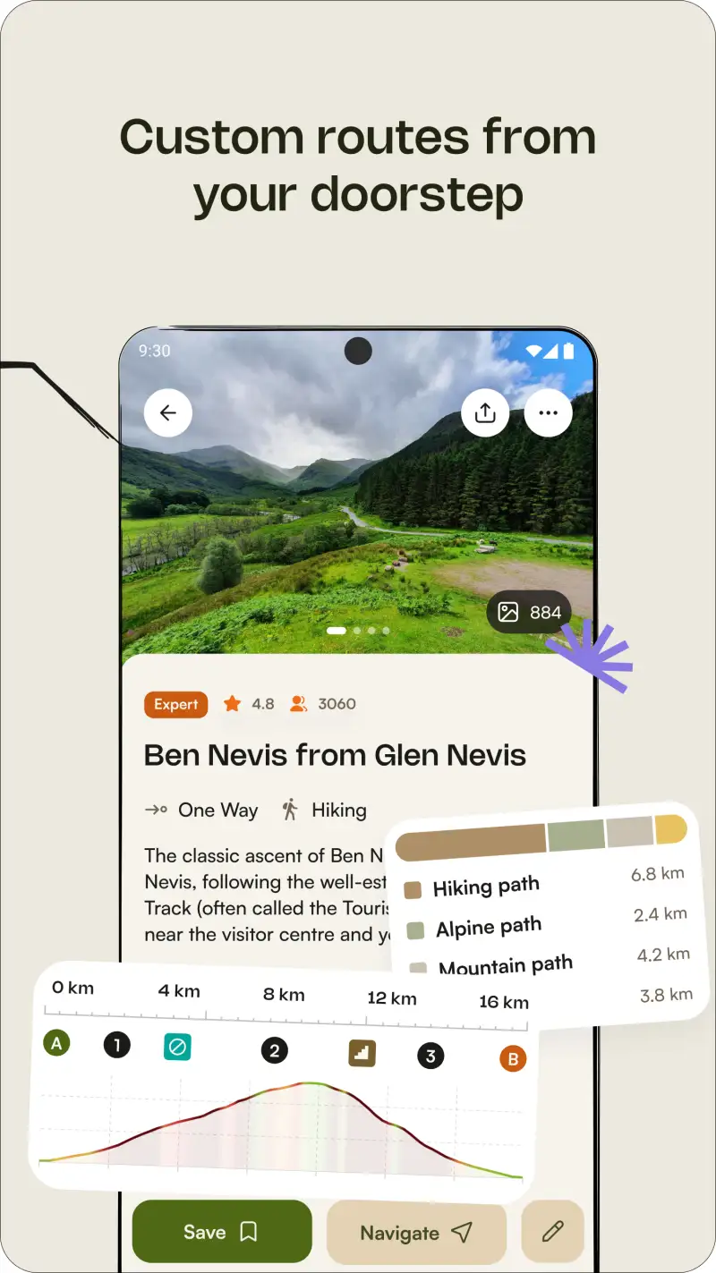
Komoot solves the gravel routing problem that road apps ignore: generating a route that actually matches your surface preference before you ride it. The routing engine understands the difference between a road bike, a gravel bike, and a mountain bike, generating routes that distinguish paved road from gravel track from dirt path from singletrack at the planning stage, shown on the elevation profile with gradient percentage per segment.
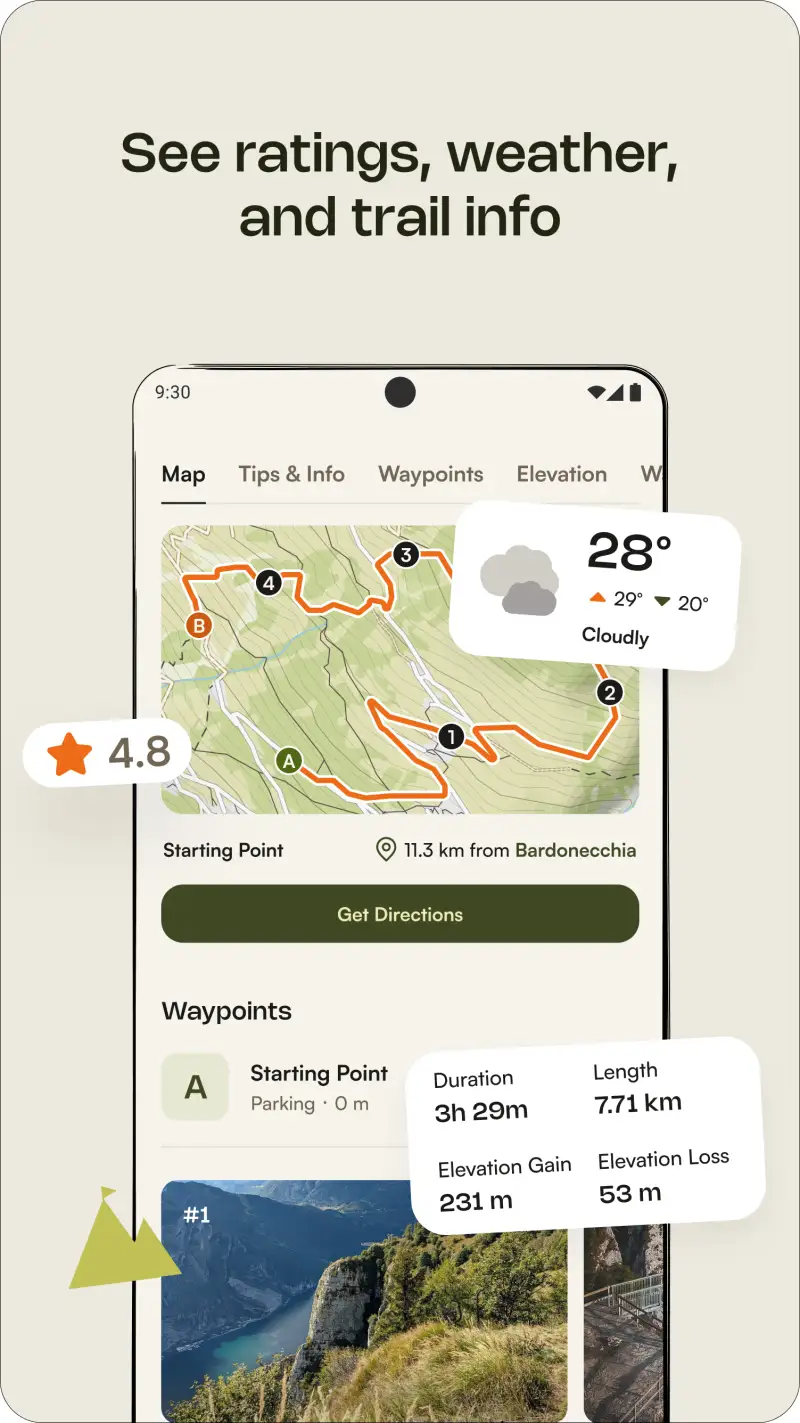
The 160,000+ community gravel routes make Komoot the strongest discovery tool for gravel riders exploring new regions. Pre-built routes from local riders include surface breakdowns, elevation profiles, and difficulty assessments, letting you evaluate a new area's riding character before visiting. Turn-by-turn voice navigation delivers junction-specific instructions on unpaved terrain, and offline map downloads ensure navigation continues when cellular coverage drops mid-route.
What Komoot does well
- Surface-aware routing: paved / gravel / dirt / singletrack displayed on the elevation profile before you ride; prevents the common gravel planning mistake of discovering an unrideable surface section mid-route
- Elevation profiles with gradient percentage per segment: see every climb, descent, and surface transition before committing to the route
- 160,000+ community gravel routes worldwide, particularly strong in Europe across the Alps, Pyrenees, and Dolomites; coverage density is weaker in parts of North America
- Turn-by-turn voice navigation with junction-specific instructions, reliable on unpaved surfaces in testing across varied gravel terrain
- Offline map downloads for areas without cellular signal, available in the free local region and the worldwide bundle
- €29.99 one-time worldwide map purchase, strong value compared to annual subscription alternatives
Where Komoot falls short
The 2025 pricing change moved Garmin and Wahoo device sync behind a Premium subscription at roughly €4.99 per month, which generated significant backlash from gravel riders who previously synced free. Community route density is noticeably weaker in North America than in Europe; riders in the Alps or Tuscany find rich pre-built gravel route libraries, while riders in parts of the American West may find limited community coverage. Komoot lacks the precision waypoint editing and cuesheet generation that RideWithGPS provides for complex multi-day route building.

Pricing: Free (one local region) / €29.99 one-time (worldwide maps) / ~€4.99/month Premium for device sync
Download Komoot and purchase the worldwide map bundle at €29.99 if you ride across multiple regions. Add Premium only when Garmin or Wahoo device sync is a specific workflow requirement. Pair Komoot with RideWithGPS for complex multi-day routes where precise waypoint management matters.
RideWithGPS - Best for Complex Multi-Day Routes
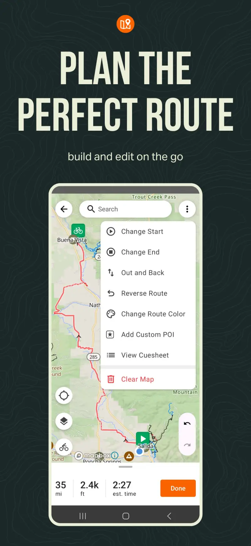
However, Komoot's route creation tools, while effective for day rides, reach their limits when planning 3-5 day bikepacking routes with specific intermediate stops. RideWithGPS addresses this gap with a precision route editor that handles drag-and-drop waypoint placement, custom point-of-interest creation, and the cuesheet generation that makes sharing routes with other riders practical.
The 2025 Surface Types feature, added specifically in response to gravel and bikepacking community demand, shows paved versus gravel versus dirt versus natural surface inline during route planning, directly competing with Komoot's surface breakdown. Elevation profiles with climb-aware time estimates personalized to your historical pace on similar gradients help with realistic daily distance planning on multi-day routes where arriving at a campsite after dark is a genuine problem.
What RideWithGPS does well
- Precision route editor: drag-and-drop waypoint placement with custom POI creation for resupply points, water sources, and campsite locations; handles multi-day route architecture that simpler tools cannot
- Surface Types (2025): paved / gravel / dirt / natural displayed inline during planning, with surface percentage shown for the full route
- Cuesheets: step-by-step turn instructions exportable for paper reference or bike computer display; particularly useful for sharing routes with bikepacking partners
- Elevation profiles with climb-aware time estimates personalized to your historical performance data, helping realistic daily distance planning
- GPX, FIT, and TCX export compatible with Garmin, Wahoo, and Hammerhead bike computers for seamless device transfer
- Large library of shared routes from the bikepacking and gravel community, especially strong for multi-day adventure routes
Where RideWithGPS falls short
The interface is less intuitive than Komoot for casual day ride discovery; RideWithGPS rewards riders who plan routes carefully rather than those who prefer browsing pre-built community options. Mobile navigation quality during the ride is functional but less polished than Komoot's turn-by-turn experience on technical terrain. The Basic subscription at $49.99 per year is required for offline maps and device sync, adding cost when combined with other subscriptions in a gravel-specific stack.
Pricing: Free (basic route planning) / $49.99/year Basic (offline maps + device sync + mobile navigation)
Download RideWithGPS free and build your next multi-day route using the precision editor before evaluating the subscription. Subscribe at $49.99 per year when offline maps and device sync become specific requirements, typically once you start planning routes beyond familiar local territory.
Gaia GPS - Best for Backcountry and Off-Grid Navigation
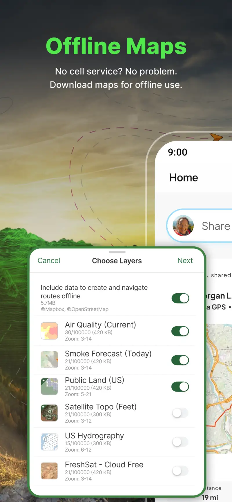
Building on the route planning tools, Gaia GPS addresses the navigation scenario that both Komoot and RideWithGPS cannot fully cover: genuinely remote terrain where no established gravel route database exists and where cellular coverage is reliably absent. For gravel riders who venture into backcountry areas, or who ride remote agricultural or forest roads with no community route data, Gaia GPS provides topographic navigation that the other apps in this guide do not match.
The multi-layer system combines topographic contours, satellite imagery, and real-time slope angle analysis on the same map view. For gravel riders planning routes in unfamiliar mountainous terrain, the slope analysis layer helps identify sections where gradient may exceed what a loaded gravel bike can practically climb, before committing to the route.
What Gaia GPS does well
- Offline topographic navigation: full-resolution topo maps downloaded before departure, fully functional without any cellular signal; essential for remote gravel and backcountry routes
- Multi-layer mapping: topographic contours + satellite imagery + slope angle analysis simultaneously, each layer individually adjustable during planning and navigation
- Slope analysis showing gradient percentage and color-coded steepness across the planned route, useful for identifying sections that may require pushing a loaded bikepacking setup
- Extensive map source library including USGS topographic data, Forest Service maps, OpenStreetMap, and satellite imagery layers
- Route recording with accurate elevation data and waypoint creation during the ride
- $39.99 per year, affordable for the level of off-grid navigation capability it provides
Where Gaia GPS falls short
The learning curve is meaningfully steeper than Komoot or RideWithGPS: comfortable proficiency with layer switching, offline map downloading, and waypoint management takes several practice sessions before the app feels intuitive during a ride. Gaia GPS is not a training platform; it has no heart rate integration, training load tracking, or performance analytics. The community route database is smaller than both Komoot and RideWithGPS for established gravel routes. Use it specifically for backcountry and remote navigation, then sync activities to Strava for the training data layer.
Pricing: Free (limited) / $39.99/year Premium (full offline maps, all layers)
Subscribe to Gaia GPS Premium and practice downloading offline maps and switching between topo and satellite layers before your first remote gravel ride. The offline preparation step is essential; arriving at a remote route without pre-downloaded maps removes the primary advantage of the app.
Strava - Best Social Layer for Gravel Riders
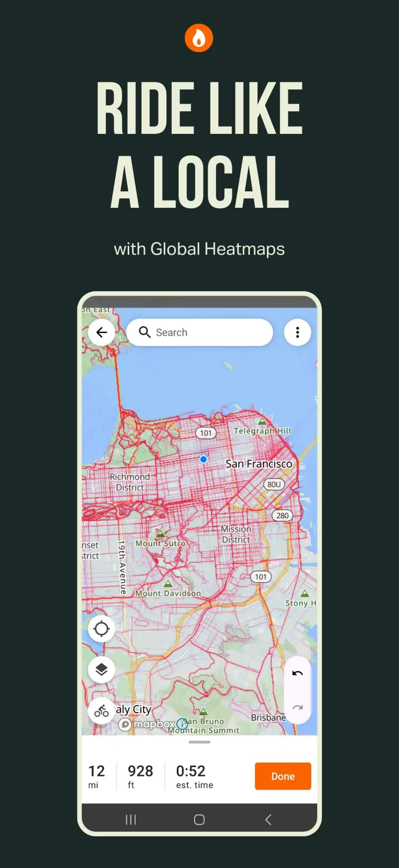
Additionally, Strava provides the community infrastructure that gravel riders share regardless of which navigation and planning tools they use. With 195 million registered users as of early 2026, Strava's heatmap routing shows where other cyclists actually ride in any region, which is genuinely useful for discovering local gravel networks in unfamiliar areas without relying entirely on community routes in Komoot or RideWithGPS.
Gravel-specific segments on popular gravel roads function as informal benchmarks between organized events. Many popular gravel routes in active cycling regions have established segments with leaderboards tracking who covers the stretch fastest, providing competitive structure without race organization. The free tier covers the segment and community features that matter most for gravel riders.
What Strava does well
- Heatmap routing: shows where cyclists actually ride in any region, revealing local gravel networks that do not appear in official route databases or community route libraries
- Segments on popular gravel roads and routes worldwide, with personal record tracking from the first ride
- Running clubs and gravel-specific groups with monthly challenges and community accountability
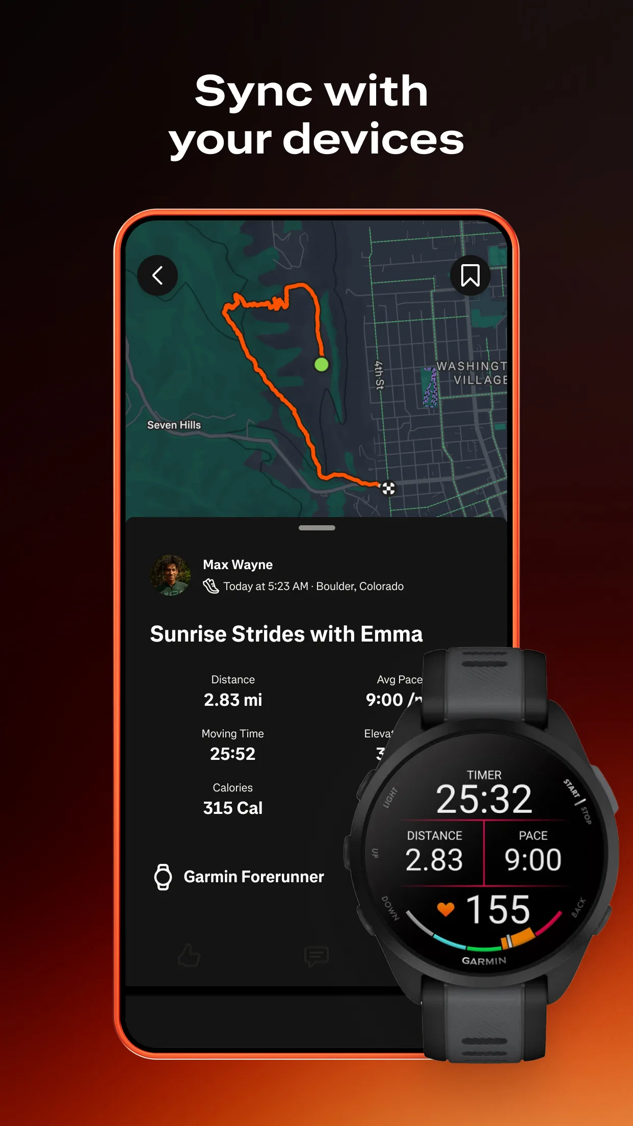
- Device sync with Garmin, Wahoo, Polar, COROS, Apple Watch, and Wear OS for automatic activity upload
- Live Segments on Premium: real-time PR comparison during the ride on compatible Garmin devices
- Free tier covers heatmap routing, segment tracking, and club membership, the primary features relevant for gravel riders
Where Strava falls short
Strava is a social tracking tool, not a navigation or route planning app. It has no surface-aware routing, no offline map capability, and no precision route building for multi-day adventures. Heart rate zone analysis and training load data moved behind the $79.99 per year paywall since 2024. For most gravel riders, the free tier covers the relevant community and segment features without requiring Premium.
Pricing: Free (tracking + social + segments) / $79.99/year Premium
Install Strava free today and use the heatmap routing feature to discover local gravel networks in your area before your next adventure. Add Premium when Live Segments and filtered leaderboards become relevant to your specific gravel routes; the free tier covers community accountability at no cost.
Garmin Connect - Best Free Analytics for Hardware Owners

Unlike the navigation-focused apps above, Garmin Connect addresses the recovery and performance analytics layer that gravel riders need during multi-day events and demanding training blocks. For riders who own Garmin hardware, it provides Body Battery, HRV Status, Training Status, and expanded gear tracking at no subscription cost beyond the hardware investment.
For multi-day bikepacking specifically, the Body Battery score is practically useful: a score below 40 after a hard first day suggests moderating pace on day two to avoid accumulated fatigue that could compromise the final days of the route. The Q1 2026 update added expanded gear tracking with component-specific mileage alerts, which matters for gravel riders who accumulate significant mileage on drivetrains and tires more quickly than road cyclists on smoother surfaces.
What Garmin Connect does well
- Body Battery and HRV Status: daily readiness data useful for multi-day ride pacing decisions; the Garmin Edge 540's 26-hour battery life makes extended multi-day use practical
- Training Status: classifies fitness trajectory as Productive, Maintaining, Peaking, or Detraining after each ride
- Expanded gear tracking (Q1 2026 update): component-specific mileage alerts for drivetrain, tires, and brake components, useful for gravel riding where component wear accelerates
- VO2max estimation and training load tracking via power meter or heart rate data
- Sync to Strava, RideWithGPS, and other platforms for automatic activity sharing
- Completely free for all Garmin device owners; Edge 540 at $399 with 26-hour battery life suited for multi-day gravel use
Where Garmin Connect falls short
Zero value without Garmin hardware. The interface is dense compared to Komoot and RideWithGPS, and Android navigation takes longer than the desktop web version. Garmin Connect does not provide route planning or navigation capability; use it specifically as the analytics layer alongside Komoot and RideWithGPS for planning and navigation.
Pricing: Free (requires Garmin device)
Activate Garmin Connect immediately if you own a Garmin device and enable HRV Status for multi-day recovery monitoring. For riders without Garmin hardware, the other four apps in this guide cover gravel-specific needs without hardware dependency.
Which App Fits Your Gravel Setup
| App | Price | Best For | Offline Maps |
|---|---|---|---|
| Komoot | Free / €29.99 one-time | Surface routing, day ride discovery | Yes |
| RideWithGPS | Free / $49.99/yr | Multi-day routes, cuesheets | Basic only |
| Gaia GPS | $39.99/yr | Backcountry, off-grid navigation | Yes |
| Strava | Free / $79.99/yr | Community, heatmap, segments | No |
| Garmin Connect | Free | Recovery analytics, gear tracking | No (hardware required) |
Day gravel rides and local discovery
Download Komoot free and explore community routes in your local region. Install Strava free for heatmap routing and segment tracking. Neither requires payment for day gravel riding, which covers most recreational gravel use cases before adding any subscriptions.
Planning a multi-day bikepacking route
Subscribe to RideWithGPS Basic at $49.99 per year for precision waypoint editing, cuesheet creation, and device sync. Add Komoot for surface-aware routing and day-of navigation. Install Strava free for community sharing after each day's stage. This three-app combination covers every planning and navigation need for multi-day self-supported bikepacking.
Backcountry and remote gravel navigation
Subscribe to Gaia GPS Premium at $39.99 per year and download offline maps for your target region before departure. Add Komoot for surface-aware route planning and Strava free for the community layer. Practice the offline map workflow on familiar terrain before relying on it in genuinely remote conditions.
Using Garmin hardware
Activate Garmin Connect for recovery monitoring and gear tracking. Add Komoot for surface-aware route planning and navigation. Sign up for Strava free for community and segment tracking. The Garmin Edge 540's 26-hour battery life makes it practical for multi-day gravel use without mid-route charging.