Resort skiers and backcountry skiers need fundamentally different apps. Slopes ($9.99/yr Premium) is the best resort skiing tracker available - auto-detecting runs, recording max speed and vertical feet, displaying a heat map of every run completed, and comparing statistics against friends at the same resort across 300+ covered destinations. Gaia GPS (bundled with Outside+ at $89.99/yr) is the essential tool for ski tourers and backcountry skiers: slope angle shading that highlights avalanche-prone terrain in orange (30-38°) and red (38°+), offline high-resolution topo, and US avalanche forecast integration that belongs in every backcountry session preparation. Strava with Outdoor Maps (formerly Fatmap, $79.99/yr) offers 3D terrain visualisation for both resort and backcountry skiing, ski resort maps for 350+ resorts, and segment competition - a middle layer that serves skiers who want terrain context and performance tracking alongside their Strava activity feed.
After testing these platforms on Pixel 8 and Samsung Galaxy S24 running Android 15, in resort and backcountry skiing contexts through the 2025-2026 winter season, I found that the divide between resort and backcountry skiing almost completely determines which app belongs in your pocket.
Who this is for: Skiers and snowboarders - resort, touring, and backcountry - who want digital tools for session tracking, terrain navigation, and performance data. If you only resort ski occasionally, Slopes free tier covers basic statistics without any subscription cost.
What Skiers Need From an App
The resort/backcountry divide creates two almost entirely separate use cases that rarely overlap in the same tool.
Resort Skiing: Automatic Run Detection and Vertical Tracking
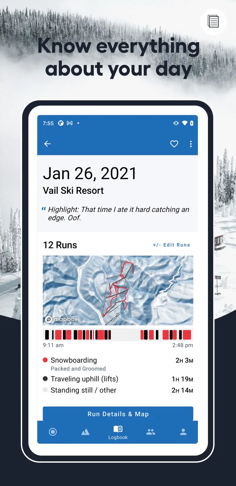
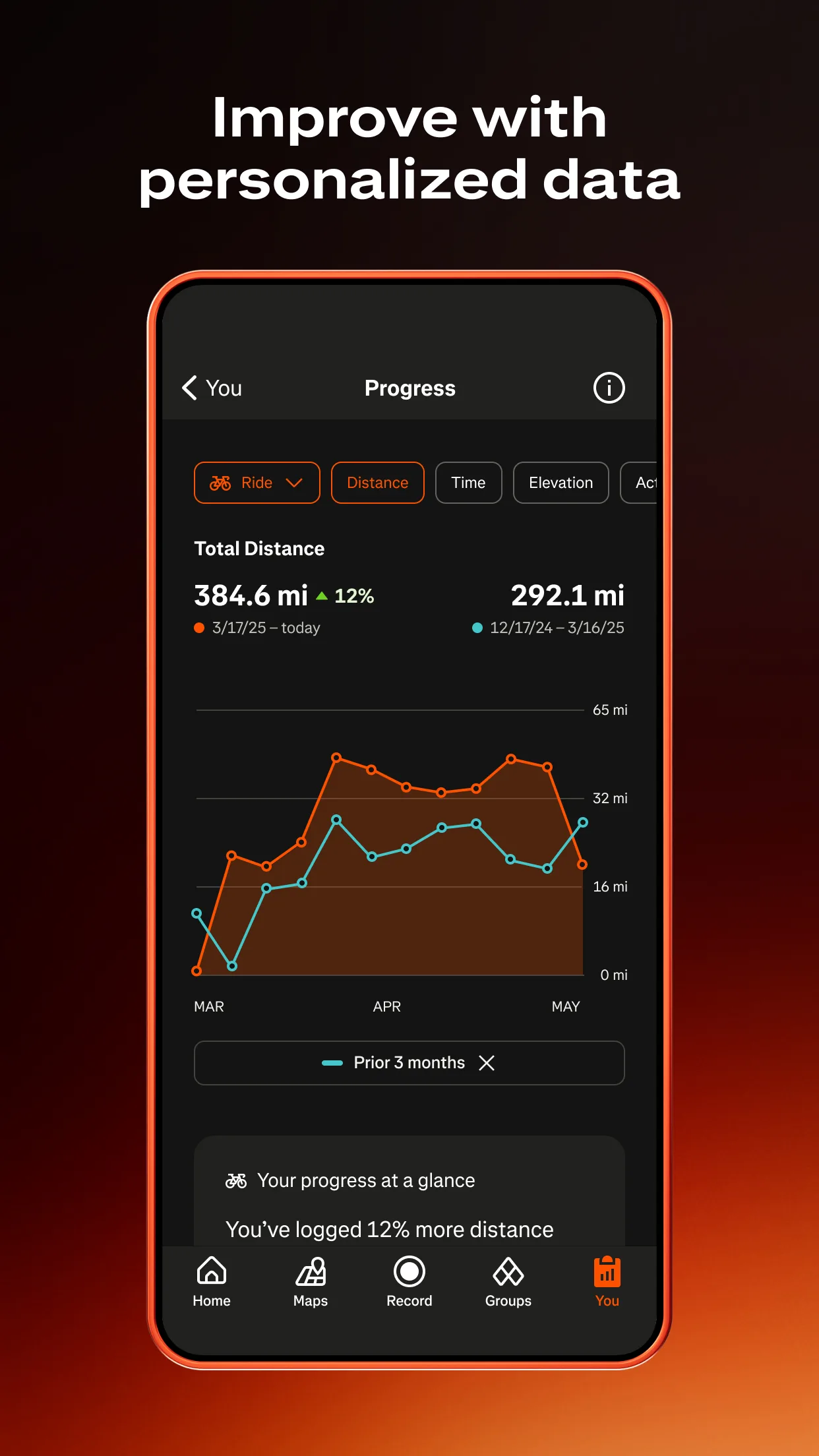
Resort skiers want their sessions documented without manual intervention - each run identified automatically, vertical feet accumulated accurately, and season totals building without any manual logging. Slopes' auto-detect run feature uses GPS and motion sensors to distinguish skiing from lift rides, recording each run separately with its own speed and vertical data. The accumulated statistics - 847,000 feet of vertical this season, 23 days, 147 runs - become the season-long record that creates year-over-year comparison and personal achievement tracking that many resort skiers find genuinely motivating.
Backcountry Skiing: Slope Angle and Avalanche Context
Backcountry skiing adds terrain safety requirements that resort apps are not designed to address. Slope angle - the gradient of terrain in degrees - is the primary avalanche risk factor: slopes of 30-38° are the most common avalanche starting zone angle; slopes above 38° are dangerously loaded. A ski tourer planning a route through unfamiliar mountains needs slope angle data overlaid on topo maps to make decisions about where to ascend, where to ski, and where to avoid. This feature exists in Gaia GPS and Strava Outdoor Maps; it does not exist in Slopes, which is designed entirely for resort use.
Terrain Visualisation for Planning
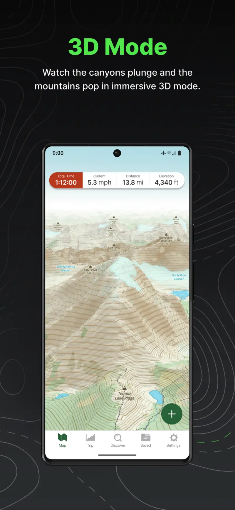
Skiers planning unfamiliar terrain - a new resort, a backcountry objective, or a resort-to-backcountry boundary area - benefit from 3D terrain visualisation that shows the actual mountain shape rather than a flat topo map. Strava Outdoor Maps' 3D rendering and Gaia GPS's topo layers both serve this need; Slopes provides 2D resort maps for its covered resorts without 3D terrain context.
Slopes - Best for Resort Skiing and Snowboarding Tracking

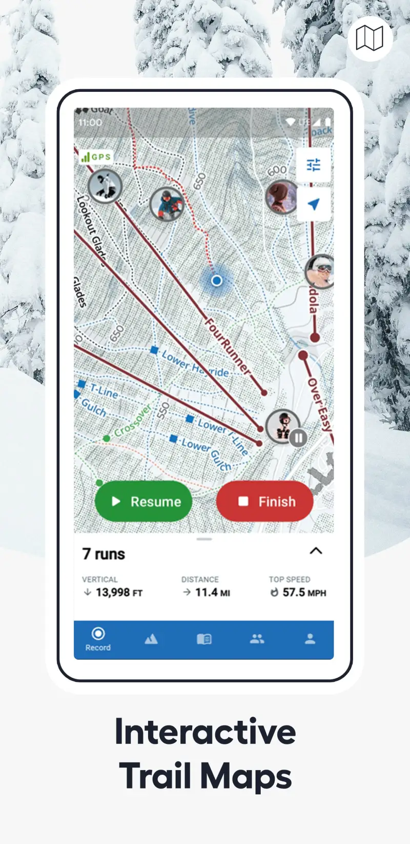

Slopes is the best resort skiing app available - 48,000+ iOS reviews at 4.8 stars and 6,200+ Android reviews at 4.5 stars reflect genuine user satisfaction at a depth uncommon in outdoor app categories. The auto-detect run feature works reliably at 300+ resorts globally, eliminating the manual logging that makes competing apps feel burdensome mid-ski day. The $9.99/yr Premium tier is the most affordable subscription in this review by a significant margin - less than two cups of coffee for a full season of analytics.
The heat map feature provides a visual record of every run completed at a resort: your GPS track overlaid on the resort map shows exactly which runs you have skied this season, where you have spent the most time, and which terrain you have not yet explored. For skiers working through a destination resort's full trail map over a multi-day trip, the heat map makes the progress visible in a way that a run count alone cannot.
What Slopes does well
- Auto-detect runs: automatically identifies each ski run and lift ride using GPS and motion sensors; no manual logging required during the ski day; works reliably at 300+ covered resorts globally
- Max speed and vertical tracking: speed per run, daily vertical feet, and lifetime accumulated vertical; the statistics that resort skiers track across seasons and years
- Heat map of completed runs: GPS overlay on resort map showing every run skied; visual progress record for skiers working through unfamiliar resort terrain
- $9.99/yr Premium: the most affordable premium ski app subscription - significantly below Strava or Gaia GPS; appropriate for occasional resort skiers who want statistics without a major subscription commitment
- 300+ resort coverage: virtually every major ski destination globally; auto-detect works at major European, North American, Japanese, and Australian resorts
- Apple Watch and Wear OS integration: basic metrics accessible on wrist during skiing without taking out phone
Where Slopes falls short
Slopes is exclusively a resort app - ski touring, backcountry skiing, and off-piste navigation are not features that Slopes is designed to address. No slope angle shading, no topo maps, no avalanche forecast integration. Backcountry skiers who attempt to use Slopes as a tracking tool outside resort boundaries will find it tracking GPS without the terrain safety context that backcountry skiing requires. Social features are limited relative to Strava - friend comparisons exist within Slopes but the community is smaller than Strava's 120M+ user base.
Pricing: Free (basic speed/vertical tracking) / $9.99/year or $1.99/month Premium (detailed analytics, heat map, offline resort maps, social features)
Resort skier or snowboarder who wants automatic session tracking and seasonal statistics? Slopes Premium ($9.99/yr) is the most affordable and most complete resort tracking solution available. Start with the free tier to verify that auto-detect works correctly at your home resort before subscribing.
Gaia GPS - Best for Backcountry Skiing and Ski Touring

However, the moment a skier leaves the resort boundary, Slopes becomes irrelevant and Gaia GPS becomes essential. The slope angle shading feature - colour-coding terrain by gradient angle with orange for 30-38° (primary avalanche starting zone) and red for 38°+ (extremely hazardous) - provides the terrain safety data that backcountry skiers use to make route decisions. A skin track planned on a Gaia GPS map with slope angle overlay visible reveals at a glance whether the intended ascent route crosses dangerous terrain that a normal topo map would not make apparent.
The US avalanche forecast integration - linking directly to regional avalanche center forecasts from the Gaia GPS map interface - combines terrain slope data with current danger ratings from professional avalanche forecasters. This combination is the minimum safe planning baseline for any backcountry skiing session: current danger rating (typically Considerable or High in active storm cycles) plus slope angle overlay to identify whether planned terrain is within appropriate risk tolerance for that danger level.
What Gaia GPS does well
- Slope angle shading: orange for 30-38° terrain, red for 38°+ terrain; the avalanche risk terrain identification layer that is the defining feature separating Gaia GPS from all resort-focused ski apps
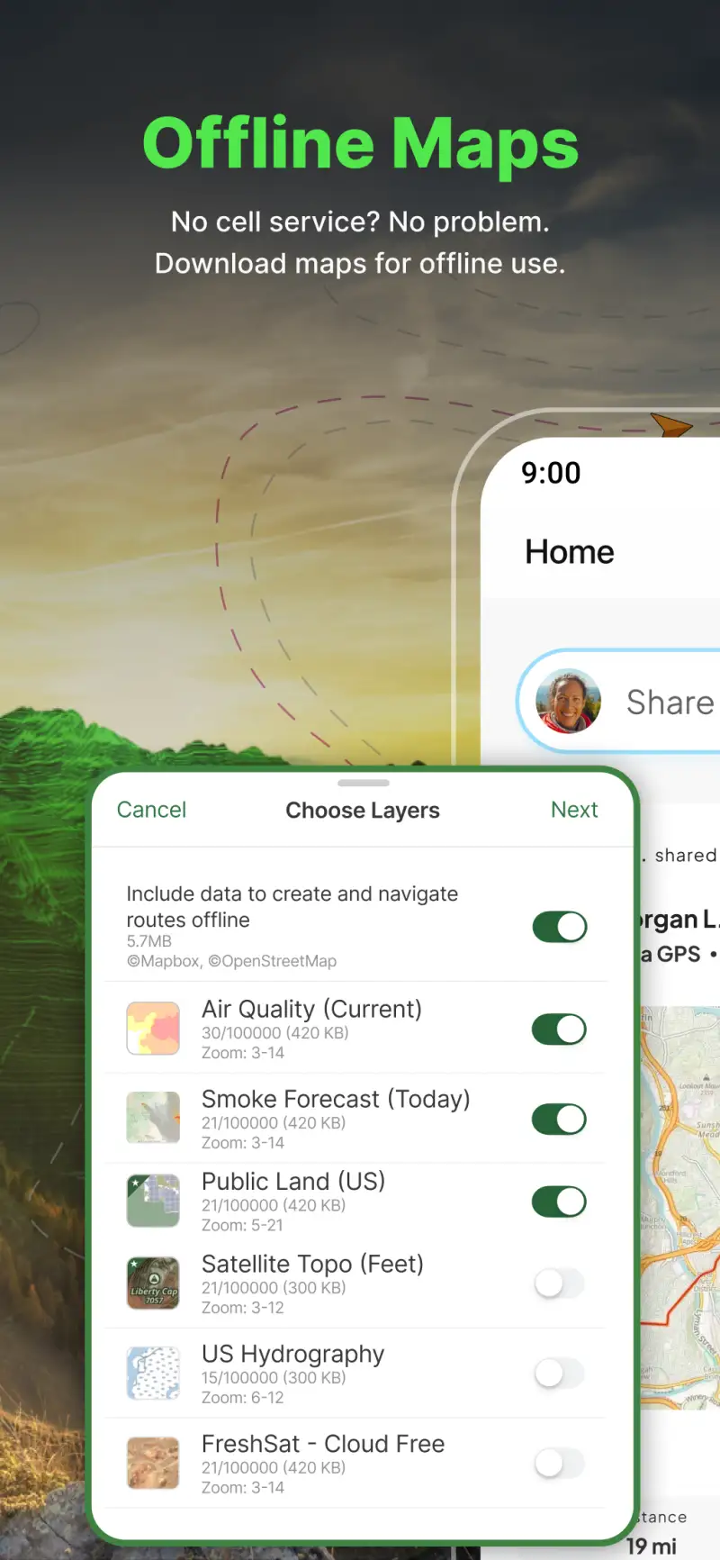
- Offline high-resolution topo: download USGS maps at multiple scales before entering no-signal backcountry terrain; the navigation baseline for any serious ski touring objective
- US avalanche forecast integration: link to regional avalanche center forecasts directly from the map; the safety data combination with slope angle that constitutes proper backcountry planning
- SNODAS snow depth layer: model-estimated snow depth data across the US; useful for evaluating whether a planned ski touring objective has sufficient snowpack
- Skin track planning: create uphill route on topo with slope angle visible; plan safe ascent lines before leaving the trailhead
Where Gaia GPS falls short
Gaia GPS is a navigation and safety tool, not a performance tracking app for skiing - there are no vertical feet counters, speed metrics, or seasonal statistics comparable to Slopes. Outside+ bundling at $89.99/yr is the only way to access Gaia GPS as of 2024; skiers who want Gaia GPS specifically must pay for a bundle that includes publications and content beyond the mapping tool. Resort skiing use of Gaia GPS (as opposed to backcountry) does not take advantage of its key features - a backcountry-oriented tool in a resort context provides less value than Slopes at 1/9th the price.
Pricing: Included in Outside+ subscription at $89.99/year (Gaia GPS Premium not available separately)
Ski tourer, backcountry skier, or anyone leaving the resort boundary? Outside+ ($89.99/yr) for Gaia GPS backcountry features is a safety investment, not just an app subscription. Every backcountry session requires checking the regional avalanche forecast (avalanche.org) regardless of whether you use Gaia GPS - the app supplements, not replaces, fundamental avalanche education.
Strava Outdoor Maps - Best for 3D Terrain and Multi-Sport Tracking
Additionally, some skiers sit between the resort-only Slopes user and the backcountry Gaia GPS user: lift-accessed off-piste terrain, resort boundary skiing, or ski mountaineers who want both performance tracking and terrain visualisation. Strava Outdoor Maps (formerly Fatmap, integrated into Strava Premium in 2024) provides 3D terrain rendering for 350+ ski resorts and broader mountain terrain, including slope angle shading that addresses the backcountry safety need while sitting within Strava's existing performance tracking infrastructure.
For skiers who already use Strava for other sports - running, cycling, summer training - the Outdoor Maps integration adds skiing-specific terrain value without requiring a separate subscription. A Strava Premium subscriber who skis in winter gets 3D ski resort terrain maps, slope angle data for off-piste exploration, and resort-specific piste maps alongside the full Strava performance tracking they already use for other activities.
What Strava Outdoor Maps does well
- 3D terrain rendering for skiing: photorealistic mountain terrain in 3D for both resort and backcountry planning; 350+ ski resort maps available within the Strava Premium interface
- Slope angle shading: avalanche terrain identification comparable to Gaia GPS; addresses backcountry safety needs within Strava's existing subscription
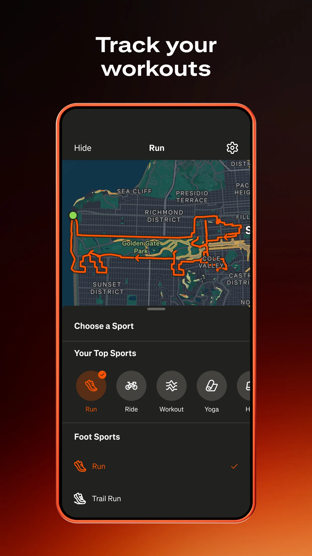
- Multi-sport integration: ski activities logged alongside running, cycling, and other Strava activities; single platform for athletes who use Strava year-round across sports
- Segment competition on ski descents: Strava segments on ski runs at popular resorts; speed and vertical leaderboards for skiers who want competitive context on regular descents
Where Strava Outdoor Maps falls short
At $79.99/yr, Strava Premium costs 8 times the Slopes Premium tier for resort skiing tracking that Slopes does more completely. Strava's run auto-detection is less reliable than Slopes' dedicated ski run detection - mixed results at correctly identifying individual runs versus lift rides in Strava compared to Slopes' resort-optimised sensors. The backcountry navigation depth is below Gaia GPS - for serious ski tourers planning complex objectives, Gaia GPS's USGS topo quality and download reliability in remote terrain exceeds Strava Outdoor Maps.
Pricing: $79.99/year or $9.99/month Premium (Strava subscription, includes Outdoor Maps)
Already subscribed to Strava Premium for running or cycling? The Outdoor Maps ski features add terrain value at no additional cost. Starting fresh specifically for skiing? Slopes ($9.99/yr) for resort tracking or Gaia GPS via Outside+ ($89.99/yr) for backcountry serve their respective use cases more effectively at similar or lower cost.
Which App Fits Your Skiing Setup
| App | Annual Cost | Best For | Resort Tracking | Backcountry Safety |
|---|---|---|---|---|
| Slopes | $9.99/yr | Resort skiing statistics | Best | No |
| Gaia GPS (Outside+) | $89.99/yr | Backcountry + ski touring | No | Best |
| Strava Outdoor Maps | $79.99/yr | Multi-sport + 3D terrain | Moderate | Good |
Resort skier or snowboarder wanting season statistics
Subscribe to Slopes Premium ($9.99/yr). The auto-detect run feature, vertical tracking, and heat map are purpose-built for resort skiing at the lowest subscription cost in this category.
Ski tourer or backcountry skier
Subscribe to Outside+ ($89.99/yr) for Gaia GPS backcountry features. Check avalanche.org for your region every session before departure - this is not optional regardless of which app you use.
Multi-sport athlete who skis in winter and trains in summer
Stay on Strava Premium ($79.99/yr) for year-round use. The Outdoor Maps ski terrain features add resort and backcountry terrain value within your existing subscription. Add Slopes free tier for more accurate resort run detection without additional cost.